
Date of Visit: 13th December 2009
On the way back from the nearby Lenyadri Caves, we decided to pay fort Shivneri a visit. It was well past two in the afternoon. The high altitude Lenyadri trip had sapped our energy, but enthusiasm to see the fort pushed us to embark on the climb.
The Fort Shivneri is located at Junnar town (which was earlier called Jeernanagar and Juner , and acted as a trade route to the Konkan ports), around 100 kms from Pune (off Narayangaon on Pune Nasik highway).It is one of the few well maintained forts in Maharashtra, thanks to the efforts of the locals and the initiatives taken by Shri A.M.Sonawane, the R.F.O, Junnar jurisdiction.

PIC: LUSH GREEN FIELDS AS SEEN FROM THE FORT
It has become memorable in history as the birthplace of Chatrapati Shivaji Maharaj, the legendary Maratha warrior king. It is unclear who actually constructed the fort, but its origins have been traced back to the Satavahana period(Their king Gautamiputra Satkarni was said to have replaced the Saka rule in this region). There were many Buddhist caves built in the vicinity. But the actual fortification may have started during the Yadava rule and continued during the Islamic rule ( Bahamani rule and later Nizamshahi of Ahmednagar). When Shahaji raje Bhosale was surrounded by enemy forces, he shifted his wife Jijabai who was pregnant with Shivaji to fort Shivneri (which was under the care of its Killedar( Fortkeeper) Sriniwas Vishwasrao).Shahajiraje ensured the streanthening of the fort to protect his family from the enemy forces. Chatrapati Shivajiraje gave up this fort in 1632 and it passed hands to the Mughals in 1637. In 1637 an attempt was made to recapture the fort by the Marathas but it was unsuccessfull. However during Chatrapati Shahurajes tenure, the Marathas surmounted the fort. The fort was later maintained by the Peshwas.
We could take our vehicle upto the foothills and parked the same below the fort.

PIC: MAHA DARWAZA
To reach the top of the fort you have to climb around 400 odd stone steps. It takes you almost one and a half hours to reach there, depending on ones stamina. To reach the top, you have to pass through seven huge fortified gates named as Maha Darwaza(Gate), Ganesh Darwaza, Pir Darwaza, Hatti(Elephant) Darwaza, Shivai (Godess temple) Darwaza ,Mena(Palanquin for the ladies) Darwaza and Kulup (lock)Darwaza.

PIC: GANESH DARWAZA

PIC: PIR DARWAZA
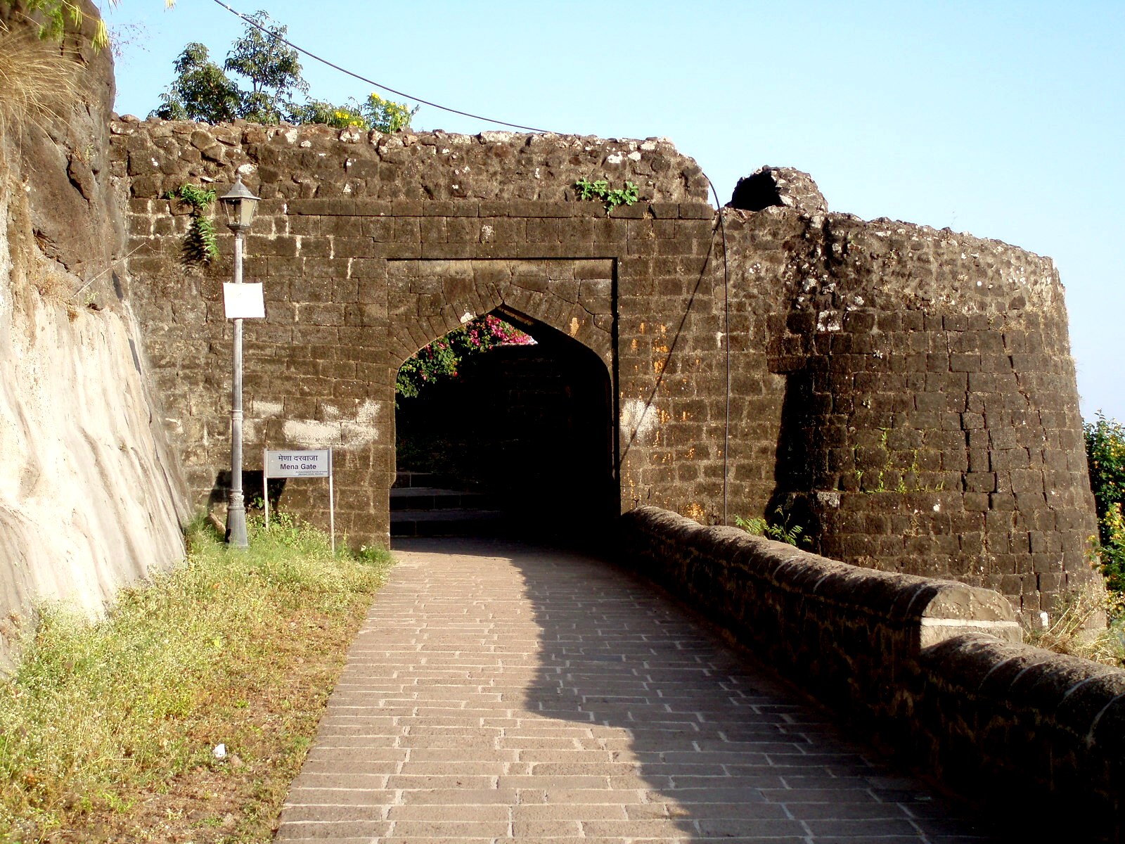
PIC: MENA DARWAZA

PIC: KULUP DARWAZA

PIC: HATTI DARWAZA
The most distinctly conspicuous gate one encounters is the Hatti darwaza (Elephant gate) due to its huge wooden doors fortified with iron spikes. It may have been named so, either because it was a gate to allow in the elephants, or the sharp iron spikes were meant to ward off even a elephant attack.

PIC: SHIVAI DARWAZA
Inside the premises you come across the temple of Shivai (pronounced Shivaaii) devi, the Godess of the Fort accessible through the Shivai Darwaza. It is to be noted that Shivaji was named after the Godess.

PIC: AMBERKHANA
As you climb further, you see the Amberkhana ruins, that probably served as the quarters for Malik Ahmed, then a Bahamani commander and later the progenitor of Nizamshahi of Ahmednagar, who first occupied the fort. It occupies an area of 20 x 10 meters and is an black stone structure. It reveals the presence of an regal structure that existed during those times. It later served as a grainery. During the times of Malojirao Bhosale (Shahajis father) it was used to redress public grievances. During Maratha rule, it was said to serve as stables for horses and also to house elephants.

PIC: GANGA JAMUNA TANK
As you proceed further, you come across large water tanks and water reservoirs(there are said to be ten water tanks on Shivneri, the main water cistern being the Ganga Jamuna), said to have been constructed during Yadava times.


Still further lies a memorial dedicated to Shivaji viz. ‘Shiv kunj’ or Shiv smarak, which was inaugurated by the first chief minister of Maharashtra, Shri Yeshwantrao Chavan. Therein lies a beautiful panchadhaatu (5 alloys) statue of Shivaji as a boy with his mother Jijabai.

PIC: KAMANI MOSQUE WITH THE ARCH PAINTED IN WHITE
To the right of Shiv kunj lies the Kamani mosque having Quranic verses engraved on its arch. This mosque was constructed by the Mughals after they had occupied the fort.

Diagonally facing the mosque is a storeyed stone building (which was I was told was reconstructed in 1925 by Chatrapati Shahu maharaj of Kolhapur and Shri Bhaskarrao Jadhav, Education secretary, Mumbai), which was the birthplace of Chatrapati Shivaji Maharaj. It was previously accessed by the ‘suryamukhi dwaar’ (sun facing door) which you come across as you walk still further. But since then , apart from the main building rest of the premises are ruins. Facing the main door (which is entered from the rear, the front cascade being Jharoka styled windows).

A few meters away from the main door is a square water reservoir made inside the stone flooring.


As you enter the main door, you first come across a room which houses a statue of Ch.Shivaji and cradle to signify his birthplace. Alongside this room is a narrow stone stairway which lead to the upper floor. There are arched windows on all sides and also the earlier mentioned jharoka windows). The ceiling is also beautifully done.

Facing the birthplace structure is the ‘Badami talao’ which was an artificially created water pool. Right in its midst is a stone pillar .


On the way back you notice an tomb like structure atop an hillock. It is the ‘Koli Chauthara’, a memorial constructed for the hundreds of ‘kolis’ (fishermen) massacared by the occupying mughals after an outbreak of a rebellion(1650). Unfortunately due to the paucity of time we weren’t able to see the monument. We later realized that we missed the ‘Kadeloat’ point as well, where prisoners sentenced to death were thrown of the cliff (kadeloat).Alongside the Kadeloat point was the Qaidkhana (prison).
Nor could we see the Idgah structure (which has some Bahamani graves) , as we hurried down the stone stairs.


But on the way back we were able to photograph the sunset which indeed looks beautiful from the fort.
Fortunately going down wasn’t as strenuous as the way up and we reached the foothill within fourty five minutes.
Having finished our exhausting but fulfilling trip, we headed back for Pune, with wonderful memories of Shivneri.
Text and photographs by Abhijit Rajadhyaksha


